Runway Visual Range (RVR) Peculiarities
You're briefing an ILS and the minimums line reads "413/24". Many helicopter pilots gloss right over that number and revert to a different approach. Fixed-wing airline crews live and die by it. As a helicopter pilot, especially one flying single-pilot IFR in a HAA or Part 135 environment, you need to understand exactly what RVR is, when it controls your approach, when you can legally use it, and what to do when it isn't being reported at all.
This article covers what RVR actually is and how it's measured, the regulations that govern it, how helicopters get to cut visibility minimums in half (and when they don't), how to find out whether an airport really has RVR equipment, and what happens when the plate publishes an RVR minimum but nobody is reporting one.
What RVR Actually Is
Runway Visual Range is not "visibility." It's a computed value representing the horizontal distance a pilot should be able to see down the runway from the approach end — specifically, the distance at which you should be able to see high-intensity runway lights or the visual contrast of other objects on the runway.

Runway Visual Range sensor unit
Three things make RVR different from the prevailing visibility in a METAR:
- It's runway-specific. RVR is measured by sensors physically located alongside a particular runway, not by an observer or sensor somewhere on the field estimating conditions in all directions.
- It's an instrument-derived, computed value. The system doesn't just measure how murky the air is. It combines the measured extinction of light through the atmosphere with the current runway light intensity setting and the ambient background light (day vs. night) to calculate how far down the runway a pilot should actually be able to see. Crank the runway lights up, and the reported RVR can improve without the fog changing at all.
- It's reported in feet, not statute miles. Values run from about 600 feet at the bottom to 6,500 feet at the top of the scale.
How It's Measured
Older RVR systems used transmissometers. A projector and a receiver mounted 250–500 feet apart, measuring how much light survived the trip between them. The FAA's current-generation systems use forward-scatter sensors: a single unit that projects a beam into a small sample volume of air and measures how much light gets scattered by fog, rain, snow, or smoke particles. More scatter equals worse visibility. The sensor unit, paired with an ambient light sensor and a data feed from the runway light system, computes an RVR value that updates continuously.
A fully instrumented runway has up to three sensors:
- Touchdown (TDZ): Abeam the touchdown zone. This is the controlling value for approach minimums.
- Midpoint (M): Abeam the middle of the runway.
- Rollout (R): Abeam the far end.
Midpoint and rollout values matter most to airplanes doing CAT II/III autolands and low-visibility takeoffs. For a helicopter shooting a CAT I ILS, the touchdown RVR is the number you care about.

How It's Reported
RVR shows up in three places:
- METAR/ATIS, appended to the visibility group when the prevailing visibility drops to 1 statute mile or less or the RVR falls to 6,000 feet or below. It looks like
R31/2400FT(Runway 31, RVR 2,400 feet) orR31/1800V3000FTwhen it's variable. AnMprefix means "less than" the lowest reportable value; aPprefix means "more than" the highest. - ATC. Tower and approach controllers have live RVR readouts and will issue current touchdown (and midpoint/rollout, when relevant) RVR when conditions require it. The ATC-issued value is the official RVR.
- Online, via the FAA's real-time RVR website at rvr.data.faa.gov. More on that below, because it's one of the most useful and least-known preflight tools out there.
Reporting increments are 100-foot steps up to 800 feet, 200-foot steps from 800 to 3,000, and 500-foot steps above that -- which is why you see values like 1,600, 2,400, and 4,000 on approach plates rather than round thousands.
The Regulatory Framework
14 CFR 91.175 — The Foundation
For everyone, the core rule is §91.175(c): to descend below DA/DH or MDA and land, the flight visibility must be at least the visibility prescribed for the procedure, and you need the required visual references in sight. Under Part 91, that's a flight visibility determination, what you, the pilot, can see from the cockpit, and reported ground visibility or RVR doesn't legally bar you from starting the approach or from landing if you genuinely have the required flight visibility at minimums.
That said, RVR is the best objective evidence available of what you'll actually see at DA, and if the reported touchdown RVR is 1,000 when your minimum is 2,400, "I had flight visibility" becomes a very hard story to sell to the FAA.
14 CFR 97.3 — The Helicopter Discount
Here's the part every instrument rated helicopter pilot should be able to recite. Under the definition of copter procedures in §97.3, a helicopter flying a conventional (non-Copter) Category I instrument approach may reduce the published Category A visibility minimum by one-half — but never below 1/4 statute mile prevailing visibility or, if RVR is reported, 1,200 RVR, whichever is greater.
The conditions and fine print, per §97.3 and AIM 10-1-2:
- 90 KIAS at the MAP. You may fly the final approach segment at speeds up to the highest approach category authorized for the procedure, but to take the visibility reduction you must slow to 90 KIAS or less by the missed approach point.
- Visibility only. There is no reduction in DA or MDA. Ever.
- Check for the note. If the plate is annotated "Visibility Reduction by Helicopters NA," the reduction doesn't apply. That annotation means obstacles penetrate the final approach obstacle identification surface, and you fly the published Cat A visibility as-is.
- Copter procedures: no reduction. COPTER-titled approaches already have helicopter minimums built in. Fly them as published.
- No CAT II reduction. Reduction of visibility minima on Category II procedures is prohibited.
- Inoperative equipment first, then the discount. If a required component (say, the MALSR) is out, apply the Inoperative Components Table from the front of the Terminal Procedures Publication to derive the corrected Category A minimum first, then apply the helicopter reduction to that corrected number.

Worked example: an ILS publishes Cat A straight-in minimums of 200-1/2, expressed as RVR 2400. Half of 2,400 is 1,200 (exactly the RVR floor) so a helicopter meeting the 90-knot condition can fly that approach to RVR 1200. If the same approach were published at 3/4 mile (RVR 4000), half would be 2,000 RVR, which is above the floor, so 2,000 RVR is your number.
Notice the precise wording of the floor: 1/4 mile prevailing visibility or, if reported, 1,200 RVR. The RVR floor only exists as an RVR value when RVR is actually being reported. That phrase matters for the scenarios below.
Part 135 — Reported Weather Controls
If you fly HAA or any other Part 135 operation, §135.225 changes the game: you may not begin the final approach segment of an instrument approach unless the airport has an approved weather reporting source and the reported weather is at or above the authorized IFR landing minimums. Where RVR is reported for the runway, the touchdown RVR is controlling for your operation (per your OpSpecs, typically C052 and related paragraphs). Under 135, "I'll take a look" is not an option. The numbers on the ATIS or from the tower decide whether you fly the approach at all. Your OpSpecs may also modify or restrict the §97.3 helicopter reduction, so be very familiar with your own authorizations.
14 CFR 91.175(h) — The Conversion Table
This is the answer to the "what if RVR isn't reported?" question, so let's put the rule on the table before we get to the scenarios. Section 91.175(h) says: if RVR minimums for takeoff or landing are prescribed in an instrument approach procedure, but RVR is not reported for the runway of intended operation, the RVR minimum shall be converted to ground visibility using the table below, and that converted value becomes the minimum for the operation.
Two caveats: the conversion is a one-way street from a prescribed RVR minimum to a ground visibility minimum: It does not let you take a reported ground visibility and manufacture an RVR out of it for CAT II/III purposes. Approaches that fundamentally require RVR (CAT II and CAT III) require actual, reported RVR. No RVR reported, no CAT II/III.
Does the Airport Actually Have RVR? Here's How You Find Out
An approach plate showing minimums "expressed in RVR" (e.g., RVR 2400) tells you that RVR equipment serves that runway — the FAA only charts RVR-format minimums where RVR reporting exists. But equipment gets decommissioned, breaks, and goes out of service for maintenance, and the plate in your EFB doesn't know that. Here's your verification stack:
1. The Chart Supplement: In the runway data for each airport, look for the RVR code: RVR–T (touchdown sensor), RVR–M (midpoint), RVR–R (rollout), or combinations. This tells you what's physically installed, and where.
2. NOTAMs: RVR systems that are out of service are NOTAMed (e.g., SLE NAV RWY 31 RVR TDZ U/S). This is the piece that catches the "plate says RVR, airport can't currently measure it" trap. Always check the NOTAMs.
3. The FAA's real-time RVR site: rvr.data.faa.gov. This is the same one-minute-update data feed ATC sees, published for flight planning. You can look up most RVR-equipped airport in the country and watch live touchdown/midpoint/rollout values. It's explicitly for planning only. The official RVR is what ATC issues, but as an HAA or part 135 pilot planning a night approach into a fog-prone valley, being able to watch the actual trend line before you ever lift is gold.
Note
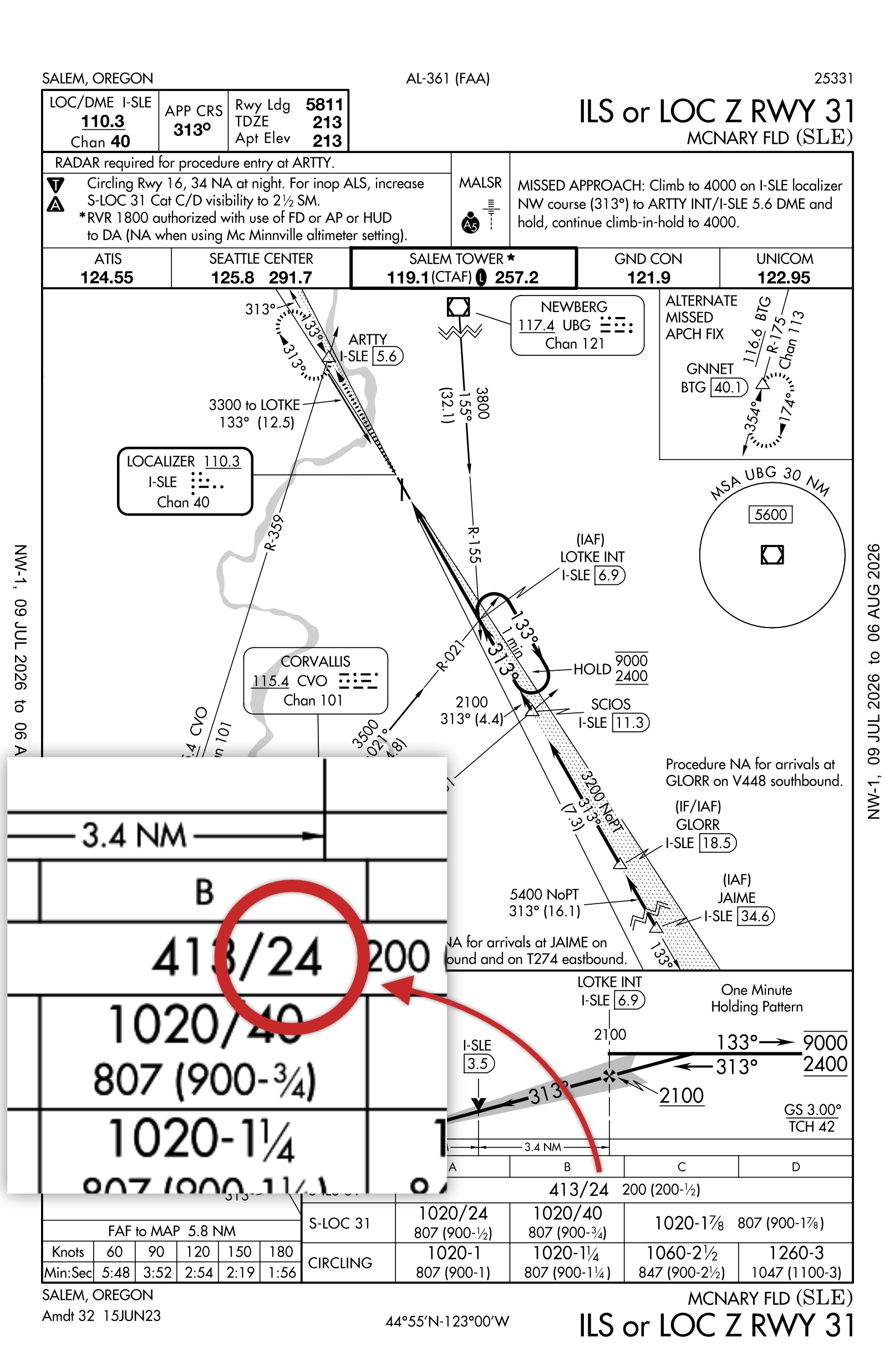
Not all RVR-equipped airports can be found on rvr.data.faa.gov. An example is McNary Field in Oregon, KSLE. Its ILS RWY 31 has published RVR minimums, yet the airport is not found on the website.
4. ATIS and ATC. If the visibility is at or below 1 SM (or RVR at or below 6,000), RVR should be appended to the ATIS and controllers will issue it. If conditions are clearly RVR-worthy and the ATIS is silent, ask. ATIS recordings go stale; the controller's display doesn't.
Real-World Examples: Three Oregon Airports
Portland International (KPDX) — The Full Setup
PDX is what a fully instrumented low-visibility airport looks like. Per the Chart Supplement, all four ends of the parallel runways (10R/28L and 10L/28R) carry RVR–TMR: touchdown, midpoint, and rollout sensors. Runway 10R adds the full CAT II/III package: ALSF-2 approach lights, touchdown zone and centerline lighting, and an ILS with published CAT II/III minimums. When the Columbia River fog rolls in, airline crews are shooting autolands to RVR values a helicopter can't legally touch — CAT II/III require specific aircraft equipment, crew training, and operational authorization, and the §97.3 helicopter reduction is prohibited on CAT II. But for a helicopter on the CAT I ILS, PDX's touchdown RVR is continuously measured, reported, and controlling (for 135), and the half-visibility rule can take a 2400-RVR CAT I minimum down to 1200 RVR.

Salem/McNary Field (KSLE) — The Partial Installation
Salem is the more instructive example, and it's a trap waiting for the unwary. The Chart Supplement shows Runway 31 with a MALSR and RVR–T — a touchdown sensor only — while Runway 13 shows RVR–R, a rollout sensor only. In practice this is one shared sensor arrangement serving both ends of the runway: the unit near the 31 threshold reads touchdown for Runway 31 and rollout for Runway 13.
Think through what that means. Shooting the ILS to Runway 31, you have genuine touchdown RVR (the controlling value) being measured. Approaching Runway 13, the only sensor on the field is at the far end of your runway, reading the visibility where you'll finish your rollout, not where you'll cross the threshold. And when Salem tower is closed (it's not a 24-hour facility), who's issuing the official RVR? This is exactly the kind of airport where it is important to check for current NOTAMS and have the 91.175(h) conversion table handy.

Eugene/Mahlon Sweet Field (KEUG) — The Fog Factory
Eugene sits at the south end of the Willamette Valley, where radiation fog can park for days in the winter. The infrastructure reflects it: Runway 16R carries ALSF-2 approach lights, touchdown zone lighting, and RVR–TMR, with a CAT II/III ILS and even an SA CAT I procedure (a Special Authorization CAT I allowing RVR 1400 minimums with a HUD, for operators approved for it). Runway 34L on the same pavement also has full RVR–TMR. If you want to watch RVR behave in real time, pull up Eugene on the FAA RVR site on a foggy December morning and watch touchdown RVR crawl from 600 toward 2400 as the sun works on the fog layer. It's the best free RVR lesson available.

Scenario Questions
"The plate publishes RVR minimums, but the airport can't actually measure RVR right now. Can I fly the RVR minimums?"
No. Not as RVR values, because there's no RVR to compare against. But you can absolutely still fly the approach. This is precisely what §91.175(h) exists for: when RVR minimums are prescribed but RVR is not reported for the runway of intended operation — because the sensor is NOTAMed out of service, or was never installed for that runway end — you convert the published RVR minimum to ground visibility using the table, and that converted value becomes your minimum.
Plate says RVR 2400? Your minimum is now 1/2 SM ground visibility. Under Part 91, you fly the approach and need 1/2 SM flight visibility at DA. Under Part 135, the reported ground visibility must be at least 1/2 SM before you begin the final approach segment. Also check the plate itself: Some procedures carry an explicit note raising minimums when RVR is inoperative, and a chart note always wins.
The one place this door stays shut: CAT II/III. Those minimums exist only as RVR, and without reported RVR they are unavailable to everyone, no conversion permitted.
"RVR isn't on the ATIS. Can I still fly the RVR minimums? Do I need the conversion table?"
First, diagnose why it's missing, because there are two very different cases:
Case 1: The weather is too good for RVR to be reported. RVR is only appended to the METAR/ATIS when prevailing visibility drops to 1 SM or less or the RVR falls to 6,000 feet or below. If the ATIS says 3 SM in mist, there's no RVR because none is required — and none is needed. You're comfortably above any RVR-format minimum on the plate, and the reported statute-mile visibility is what a 135 operator compares against minimums (using the conversion table's equivalencies: your RVR 2400 minimum equates to 1/2 SM, and you have 3).
Case 2: The weather is low and RVR still isn't being reported. Sensor out of service, tower closed, or no equipment on that runway end. Now the equipment isn't reporting, so legally "RVR is not reported for the runway of intended operation," and yes, §91.175(h) applies: convert the published RVR minimum to ground visibility and use that. Before you accept the conversion, though, ask the controller. ATIS recordings can be slow to roll out; the tower's RVR readout is instant and controlling. If ATC can issue you a current touchdown RVR, that's the official value and that's what you use.
One helicopter-specific subtlety worth knowing: the §97.3 floor is "1/4 statute mile prevailing visibility or, if reported,1,200 RVR." When RVR isn't reported, your reduced-visibility floor is 1/4 SM, which, per the conversion table, corresponds to RVR 1600, not 1200. In other words, the deepest helicopter discount (1200 RVR) only exists when a live RVR sensor is backing it up. Lose the sensor, and your floor effectively rises. That's not an accident; it's the system demanding better measured evidence before it lets you descend toward the least visibility.
Putting It Together: A Preflight RVR Checklist
- Read the minimums line. Are Cat A minimums expressed in RVR? Note the value and the equivalent statute miles.
- Check for the note. "Visibility Reduction by Helicopters NA" removes the §97.3 discount. A COPTER procedure means published minimums, no reduction allowed.
- Chart Supplement. Confirm what RVR equipment (T/M/R) serves your runway end.
- NOTAMs. Is the RVR system, the approach lighting, or anything else in the visibility chain out of service? Apply the inop components table first, then the helicopter reduction.
- rvr.data.faa.gov. Watch the live values and trend before departure.
- Compute your personal minimum. Published Cat A visibility → inop corrections → halve it (if eligible and slowing to 90 KIAS by the MAP) → apply the floor: 1,200 RVR if reported, 1/4 SM if not.
- In the air, get the current number from ATC, not the ATIS timestamped 55 minutes ago.
- Part 135? Reported weather must be at or above your minimums before the FAF, touchdown RVR controlling where reported — and your OpSpecs have the final word.
RVR is one of those subjects that separates pilots who fly approaches from pilots who understand them. The equipment is measuring exactly one thing: whether the visual segment of your approach (the last, lowest, most dangerous part) is survivable.